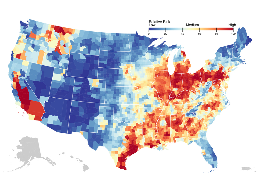
A computational tool developed by researchers at the MIT Joint Program on the Science and Policy of Global Change pinpoints specific counties within the United States that are particularly vulnerable to economic distress resulting from a transition from fossil fuels to low-carbon energy sources. By combining county-level data on employment in fossil fuel (oil, natural gas, and coal) industries with data on populations below the poverty level, the tool identifies locations with high risks for transition-driven economic hardship. It turns out that many of these high-risk counties are in the south-central U.S., with a heavy concentration in the lower portions of the Mississippi River.
The computational tool, which the researchers call the System for the Triage of Risks from Environmental and Socio-economic Stressors (STRESS) platform, almost instantly displays these risk combinations on an easy-to-read visual map, revealing those counties that stand to gain the most from targeted green jobs retraining programs.
Drawing on data that characterize land, water, and energy systems; biodiversity; demographics; environmental equity; and transportation networks, the STRESS platform enables users to assess multiple, co-evolving, compounding hazards within a U.S. geographical region from the national to the county level. Because of its comprehensiveness and precision, this screening-level visualization tool can pinpoint risk “hot spots” that can be subsequently investigated in greater detail. Decision-makers can then plan targeted interventions to boost resilience to location-specific physical and economic risks.
The platform and its applications are highlighted in a new study in the journal Frontiers in Climate.
“As risks to natural and managed resources — and to the economies that depend upon them — become more complex, interdependent, and compounding amid rapid environmental and societal changes, they require more and more human and computational resources to understand and act upon,” says MIT Joint Program Deputy Director C. Adam Schlosser, the lead author of the study. “The STRESS platform provides decision-makers with an efficient way to combine and analyze data on those risks that matter most to them, identify ‘hot spots' of compounding risk, and design interventions to minimize that risk.”
In one demonstration of the STRESS platform’s capabilities, the study shows that national and global actions to reduce greenhouse gas emissions could simultaneously reduce risks to land, water, and air quality in the upper Mississippi River basin while increasing economic risks in the lower basin, where poverty and unemployment are already disproportionate. In another demonstration, the platform finds concerning “hot spots” where flood risk, poverty, and nonwhite populations coincide.
The risk triage platform is based on an emerging discipline called multi-sector dynamics (MSD), which seeks to understand and model compounding risks and potential tipping points across interconnected natural and human systems. Tipping points occur when these systems can no longer sustain multiple, co-evolving stresses, such as extreme events, population growth, land degradation, drinkable water shortages, air pollution, aging infrastructure, and increased human demands. MSD researchers use observations and computer models to identify key precursory indicators of such tipping points, providing decision-makers with critical information that can be applied to mitigate risks and boost resilience in natural and managed resources. With funding from the U.S. Department of Energy, the MIT Joint Program has since 2018 been developing MSD expertise and modeling tools and using them to explore compounding risks and potential tipping points in selected regions of the United States.
Current STRESS platform data includes more than 100 risk metrics at the county-level scale, but data collection is ongoing. MIT Joint Program researchers are continuing to develop the STRESS platform as an “open-science tool” that welcomes input from academics, researchers, industry and the general public.