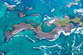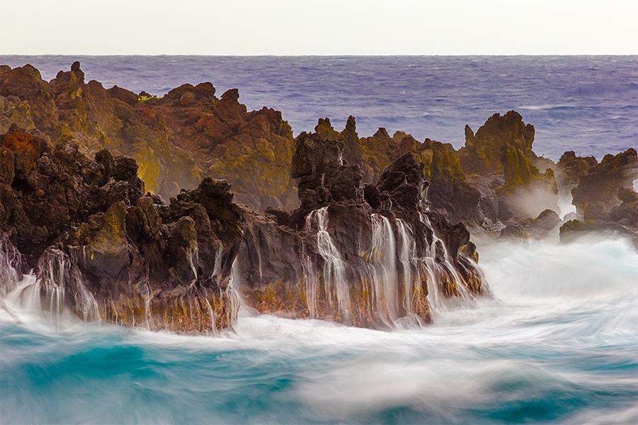
Over millions of years, Hawaiian volcanoes have formed a chain of volcanic islands stretching across the Northern Pacific, where ocean waves from every direction, stirred up by distant storms or carried in on tradewinds, have battered and shaped the islands’ coastlines to varying degrees.
Now researchers at MIT and elsewhere have found that, in Hawaii, the amount of energy delivered by waves averaged over each year is a good predictor of how fast or slow a rocky coastline will erode. If waves are large and frequent, the coastline will erode faster, whereas smaller, less frequent waves will result in a slower-eroding coast.
Their study helps to explain the Hawaiian Islands’ meandering shorelines, where north-facing sea cliffs, experiencing larger waves produced by distant storms and persistent tradewinds, have eroded farther inland. In contrast, south-facing coasts typically enjoy calmer waters, smaller waves, and therefore less eroded coasts.
The results, published this month in the journal Geology, can also help scientists forecast how fast other rocky coasts around the world might erode, based on the power of the waves that a coast typically experiences.
“Over half of the world’s oceanic coastlines are rocky sea cliffs, so sea-cliff erosion affects a lot of coastal inhabitants and infrastructure,” says Kim Huppert ’11, PhD ’17, lead author of the study and a former graduate student in MIT’s Department of Earth, Atmospheric and Planetary Sciences. “If storminess increases with climate change, and waves get bigger, we need to understand specifically how waves affect erosion.”
Huppert, who is now a senior research scientist at the German Research Center for Geosciences, has co-authored the paper with Taylor Perron, professor of earth, atmospheric, and planetary sciences and associate department head at MIT, and Andrew Ashton of the Woods Hole Oceanographic Institution.
Sink and carve
Scientists have had some idea that the rate of coastal erosion depends on the power of the waves that act on that coast. But until now, there’s been no systematic study to confirm this relationship, mainly because there can be so many other factors contributing to coastal erosion that can get in the way.
The team found the Hawaiian Islands provide an ideal environment in which to study this relationship: The islands are all made from the same type of bedrock, meaning they wouldn’t have to account for multiple types of rock and sediment and their differences in erosion; and the islands inhabit a large oceanic basin that produces a wide range of wave “climates,” or waves of varying sizes and frequencies.
“As you go around the shoreline of different islands, you see very different wave climates, simply by turning a corner of the island,” Huppert notes. “And the rock type is all the same. So Hawaii is a nice natural laboratory.”
The researchers focused their study on 11 coastal locations around the islands of Hawaii, Maui, and Kaho‘olawe, each facing different regions of the Pacific that produce varying sizes and frequencies of waves.
Before considering the wave power at these various locations, they first worked to estimate the average rate at which the sea cliffs at each coastal location eroded over the last million years. The team sought to identify the erosion rates that produced the coastal profiles of Hawaiian Islands today, given the islands’ original profiles, which can be estimated from each island’s topography. To do this, they first had to account for changes in each island’s vertical motion and sea level change over time.
After a volcanic island forms, it inevitably starts to subside, or sink under its own weight. As an island sinks, the level at which the sea interacts with the island changes, just as if you were to lower yourself into a pool: The water’s surface may start at your ankles, and progressively lap at your knees, your waist, and eventually your shoulders and chin.
For an island, the more slowly it sinks, the more time the sea has to carve out the coastline at a particular elevation. In contrast, if an island sinks quickly, the sea has only fleeting time to cut into the coast before the island subsides further, exposing a new coastline for the sea to wear away. As a result, the rate at which an island sinks strongly affects how far the coast has retreated inland at any given elevation, over millions of years.
To calculate the speed of island sinking, the team used a model to estimate how much the lithosphere, the outermost layer of the Earth on which volcanic islands sit, sagged under the weight of each Hawaiian volcano formed in the past million years. Because the Hawaiian Islands are close together, the sinking of one island can also affect the sinking or rising of neighboring islands, similar to the way one child may bounce up as another child sinks into a trampoline.
The team used the model to simulate various possible histories of island sinking over the last million years, and the subsequent erosion of sea cliffs and coastlines. They looked for the scenario that best linked the islands’ original coastlines with today’s modern coastlines, and matched the various resulting erosion rates to the 11 locations that they focused on in their study.
“We found erosion rates that vary from 17 millimeters per year to 118 millimeters per year at the different sites,” Huppert says. “The upper end of that range is nearly half a foot per year, so some of those rates are pretty fast for rock.”
Waves of a size
They chose the 11 coastal locations in the study for their variability: Some sea cliffs face north, where they are battered by stronger waves produced by distant storms. Other north-facing coasts experience tradewinds that come from the northeast and produce waves that are smaller but more frequent. The coastal locations that face southward experience smaller, less-frequent waves in contrast.
The team compared erosion rates at each site with the typical wave power experienced at each site, which they calculated from wave height and frequency measurements derived from buoy data. They then compared the 11 locations’ wave power to their long-term rates of erosion.
What they found was a rather simple, linear relationship between wave power and the rate of coastal erosion. The stronger the waves that a coast experiences, the faster that coast erodes. Specifically, they found that waves of a size that occur every few days might be a better indicator of how fast a coast is eroding than larger but less frequent storm waves. That is, if waves on normal, nonstormy days are large, a coast is likely eroding quickly; if the typical waves are smaller, a coast is retreating more slowly.
The researchers say carrying out this study in Hawaii allowed them to confirm this simple relationship, without confounding natural factors. As a result, scientists can use this relationship to help predict how rocky coasts in other parts of the world may change, with variations in sea level and wave activity as a result of climate change.
“Sea level is rising along much of the world’s coasts, and changes in winds and storminess with ongoing climate change could alter wave regimes, too,” Perron points out. “To be able to isolate the influence of wave climate on the rate of coastal erosion gets you one step closer to going to a particular place and calculating the change in erosion rate there.”
This research was supported, in part, by the NEC Corporation, and by NASA.