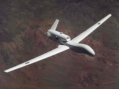
In June, the Federal Aviation Administration (FAA) agreed to expand flights of unmanned aerial vehicles, or drones, along the Texas-Mexico border for surveillance purposes. Although unmanned aircraft have been used extensively by the military in Afghanistan and Iraq, the FAA has been hesitant to issue flying rights for the pilotless vehicles in the U.S. other than on a case-by-case basis, such as for border patrol. Last year, the agency promised defense officials it would unveil a plan for regulating unmanned planes this year, and it recently opened a new lab to explore how air traffic control systems can control unmanned aircraft for civilian and law-enforcement purposes. As the FAA appears to make progress with regulating UAVs, MIT News sat down with Nicholas Roy, an associate professor in MIT’s Department of Aeronautics and Astronautics and director of the Robust Robotics Group, to discuss the challenges involved with flying unmanned planes across America.
Q. What are the advantages and disadvantages of using unmanned planes for non-military purposes?
A. There are a number of advantages of using UAVs for non-military purposes, and the advantages to a large extent depend on the application. The primary application of UAVs so far, for both military and non-military purposes, has been to act as a sensor platform. Just as an example, in addition to military and border surveillance, UAVs carrying atmospheric sensors can take targeted measurements to improve our ability to predict weather and climate conditions. One major advantage of using a UAV is that these vehicles have the potential to stay in the air much longer than manned aircraft. Secondly, UAVs come in a variety of shapes and sizes, and some UAVs are much smaller than a manned aircraft could ever be. A micro UAV (or MAV) carrying imaging sensors can be used in urban environments to provide police and first responders with accurate situational awareness in the event of a disaster scenario. Another major advantage of using small-scale MAVs is that they can operate in confined spaces, such as indoors or in the urban canyon, providing information to people outside the area in a way that manned aircraft and ground vehicles cannot currently.
There are also a number of disadvantages to UAVs currently. First, from an engineering perspective, a human pilot currently gives the vehicle an enormous edge in capability. Autonomous controllers and autopilots continue to grow in sophistication, but this technology is still limited compared to what human pilots can make an air vehicle do, and limited in terms of the conditions under which an autopilot can fly. Secondly, UAVs rely very heavily on external infrastructure, such as GPS and tight network connectivity to a ground station. As a result, UAVs are very good at projecting information and situational awareness back to ground stations, but at a substantial cost in terms of human support.
Q. Why is it so tricky to regulate UAVs for non-military use? What are the technological challenges involved, and how does the FAA plan to address these?
A. When discussing large-scale UAVs (i.e., not human-portable MAVs), there is a logistical challenge of integrating the UAV not only into the airspace, but also into the infrastructure currently supporting commercial and general aviation. UAVs must be able to interact with air-traffic control and the pilots of other aircraft. This requires either substantial advances in human-robot interaction, such as speech recognition, or modification of how aircraft communicate with each other and the ground. Additionally, regulations such as right-of-way rules designed to ensure collision avoidance, also known as deconfliction, create technological challenges of developing sensors and sensor-processing algorithms that can perceive other aircraft at specific distances and sizes.
Finally, ensuring safety and minimizing risk is a challenge for both military and non-military vehicles. Air vehicles of all shapes and sizes have always been extremely safe but are becoming increasingly complex in almost every measure such as design, capability, number of components, scope of operation, etc. The growth in complexity of the entire system poses challenges for us as engineers in terms of being able to test a system, identify potential faults and certify the vehicle. Ensuring the safe operation of an autonomous perception and control system that is required to fly a UAV in unstructured environments is a challenge for all autonomous vehicles.
Q. The FAA is expected to move from a radar-based traffic control system to a GPS-based one within the next decade. How exactly will this make it easier to track UAVs and prevent collisions?
A. GPS does not necessarily make it easier to track UAVs — there has been enormous effort in developing and deploying the satellite infrastructure, and each vehicle will require the appropriate equipment not only to track its position using GPS but also to broadcast that estimate. The expectation is that GPS will provide faster, more accurate and more precise measurements of each vehicle in the air. These improvements should allow for faster air traffic control decisions and may increase the number of available routes for aircraft to fly, which may in turn reduce the effort required to avoid collisions.
However, the plans for GPS-based air traffic control involve more than just GPS, as the position information can be accompanied by additional data about the vehicle, including identity information. This is especially useful for UAV autopilots, which can use this additional source of digitally encoded information to build situational awareness and make local decisions about trajectories. Without GPS information from other vehicles, the demands on the sensors onboard the UAV to avoid collisions are substantial.
Safety of course is paramount, and GPS is not a magic bullet. It can be subject to errors or noisy measurements, just as radar-based systems can. Switching from one sensor modality to another requires careful planning and an awareness of its limitations.
