Professor Dara Entekhabi will lead the science team designing a NASA satellite mission to collect global soil moisture measurements and other data seen as key to improving weather, flood and drought forecasts and predictions of agricultural productivity and climate change.
At present, scientists have no network for gathering soil moisture data as they do for rainfall, winds, humidity and temperature. Instead, that data is gathered only at a few scattered points around the world. But NASA's Soil Moisture Active-Passive mission (SMAP), scheduled to launch in December 2012, aims to change that.
"Soil moisture is the lynchpin of the water, energy and carbon cycles over land. It is the variable that links these three cycles through its control on evaporation and plant transpiration. Global monitoring of this variable will allow a new perspective on how these three cycles work and vary together in the Earth system," said Entekhabi, Bacardi and Stockholm Water Foundations Professor.
"Additionally, because soil moisture is a state variable that controls both water and energy fluxes at the land surface, we anticipate that assimilation of the global observations will improve the skill in numerical weather prediction, especially for events that are influenced by these fluxes at the base of the atmosphere," added Entekhabi, who holds joint appointments in MIT's Department of Civil and Environmental Engineering and the Department of Earth, Atmospheric and Planetary Sciences and is also director of the Parsons Laboratory for Environmental Science and Engineering.
The SMAP mission is based on an earlier satellite project led by Entekhabi that had been selected by NASA from among 20 proposals and scheduled for a 2009 launch. However, the Hydrosphere State Mission (Hydros) was cancelled abruptly in 2005 when funding for NASA's earth sciences missions was diverted. But in July 2007, the National Research Council recommended that NASA make the soil moisture measurement project a top priority and place it on a fast track for launch. The Jet Propulsion Laboratory in Pasadena, Calif., is the lead NASA center for the project.
SMAP's launch in 2012 is feasible in part because Entekhabi and other scientists continued to develop the mission, even when NASA's support was withdrawn in 2005.
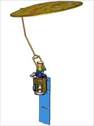
The instruments that will be deployed in SMAP will gather both passive and active low-frequency microwave measurements on a continuous basis, essentially creating a map of global surface soil moisture. A 6-meter deployable mesh antenna on a satellite will gather data across a swath of 1,000 kilometers, creating ribbons of measurements around the globe and completing the cycle every few days.
In addition to measuring soil moisture, the satellite will detect if the surface moisture is frozen. In forests, the freeze/thaw state determines the length of the growing season and the balance between carbon assimilation into biomass and the loss of carbon due to vegetation respiration. The result of this balance can tell scientists if a forest is a net source or net sink of carbon.
One mission obstacle that Entekhabi and team solved last year was integrating the two types of measurements the satellite would gather: passive measurements collected by radiometer, and active collected by radar. The radiometer measurements provide highly accurate data at a coarse resolution of 40 kilometers. The radar measurements provide much higher resolution (3 kilometers), but with less sensitivity. The combination of the two measurements through algorithms designed by the SMAP science team will result in accurate mapping of global soil moisture at 10 kilometers.
A version of this article appeared in MIT Tech Talk on April 30, 2008 (download PDF).