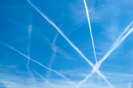
Aviation’s climate impact is partly due to contrails — condensation that a plane streaks across the sky when it flies through icy and humid layers of the atmosphere. Contrails trap heat that radiates from the planet’s surface, and while the magnitude of this impact is uncertain, several studies suggest contrails may be responsible for about half of aviation’s climate impact.
Pilots could conceivably reduce their planes’ climate impact by avoiding contrail-prone regions, similarly to making altitude adjustments to avoid turbulence. But to do so requires knowing where in the sky contrails are likely to form.
To make these predictions, scientists are studying images of contrails that have formed in the past. Images taken by geostationary satellites are one of the main tools scientists use to develop contrail identification and avoidance systems.
But a new study shows there are limits to what geostationary satellites can see. MIT engineers analyzed contrail images taken with geostationary satellites, and compared them with images of the same areas taken by low-Earth-orbiting (LEO) satellites. LEO satellites orbit the Earth at lower altitudes and therefore can capture more detail. However, since LEO satellites only snap an image as they fly by, they capture images of the same area far less frequently than geostationary (GEO) satellites, which continuously image the same region of the Earth every few minutes.
The researchers found that geostationary satellites miss about 80 percent of the contrails that appear in LEO imagery. Geostationary satellites mainly see larger contrails that have had time to grow and spread across the atmosphere. The many more contrails that LEO satellites can pick up are often shorter and thinner. These finer threads likely formed immediately from a plane’s engines and are still too small or otherwise not distinct enough for geostationary satellites to discern.
The study highlights the need for a multiobservational approach in developing contrail identification and avoidance systems. The researchers emphasize that both GEO and LEO satellite images have their strengths and limitations. Observations from both sources, as well as images taken from the ground, could provide a more complete picture of contrails and how they evolve.
“With more ‘eyes’ on the sky, we could start to see what a contrail’s life looks like,” says Prakash Prashanth, a research scientist in MIT’s Department of Aeronautics and Astronautics (AeroAstro). “Then you can understand what are its radiative properties over its entire life, and when and why a contrail is climatically important.”
The new study appears today in the journal Geophysical Research Letters. The study’s MIT co-authors include first author Marlene Euchenhofer, a graduate student in AeroAstro; Sydney Parke, an undergraduate student; Ian Waitz, the Jerome C. Hunsaker Professor of Aeronautics and Astronautics and MIT’s vice president of research; and Sebastian Eastham of Imperial College London.
Imaging backbone
Contrails form when the exhaust from planes meets icy, humid air, and the particles from the exhaust act as seeds on which water vapor collects and freezes into ice crystals. As a plane moves forward, it leaves a trail of condensation in its wake that starts as a thin thread that can grow and spread over large distances, lasting for several hours before dissipating.
When it persists, a contrail acts similar to an ice cloud and, as such, can have two competing effects: one in which the contrail is a sort of heat shield, reflecting some incoming radiation from the sun. On the other hand, a contrail can also act as a blanket, absorbing and reflecting back some of the heat from the surface. During the daytime, when the sun is shining, contrails can have both heat shielding and trapping effects. At night, the cloud-like threads have only a trapping, warming effect. On balance, studies have shown that contrails as a whole contribute to warming the planet.
There are multiple efforts underway to develop and test aircraft contrail-avoidance systems to reduce aviation’s climate-warming impact. And scientists are using images of contrails from space to help inform those systems.
“Geostationary satellite images are the workhorse of observations for detecting contrails,” says Euchenhofer. “Because they are at 36,000 kilometers above the surface, they can cover a wide area, and they look at the same point day and night so you can get new images of the same location every five minutes.”
But what they bring in rate and coverage, geostationary satellites lack in clarity. The images they take are about one-fifth the resolution of those taken by LEO satellites. This wouldn’t be a surprise to most scientists. But Euchenhofer wondered how different the geostationary and LEO contrail pictures would look, and what opportunities there might be to improve the picture if both sources could be combined.
“We still think geostationary satellites are the backbone of observation-based avoidance because of the spatial coverage and the high frequency at which we get an image,” she says. “We think that the data could be enhanced if we include observations from LEO and other data sources like ground-based cameras.”
Catching the trail
In their new study, the researchers analyzed contrail images from two satellite imagers: the Advanced Baseline Imager (ABI) aboard a geostationary satellite that is typically used to observe contrails and the higher-resolution Visible Infrared Radiometer Suite (VIIRS), an instrument onboard several LEO satellites.
For each month from December 2023 to November 2024, the team picked out an image of the contiguous United States taken by VIIRS during its flyby. They found corresponding images of the same location, taken at about the same time of day by the geostationary ABI. The images were taken in the infrared spectrum and represented in false color, which enabled the researchers to more easily identify contrails that formed during both the day and night. The researchers then worked by eye, zooming in on each image to identify, outline, and label each contrail they could see.
When they compared the images, they found that GEO images missed about 80 percent of the contrails observed in the LEO images. They also assessed the length and width of contrails in each image and found that GEO images mostly captured larger and longer contrails, while LEO images could also discern shorter, smaller contrails.
“We found 80 percent of the contrails we could see with LEO satellites, we couldn’t see with GEO imagers,” says Prashanth, who is the executive officer of MIT’s Laboratory for Aviation and the Environment. “That does not mean that 80 percent of the climate impact wasn’t captured. Because the contrails we see with GEO imagers are the bigger ones that likely have a bigger climate effect.”
Still, the study highlights an opportunity.
“We want to make sure this message gets across: Geostationary imagers are extremely powerful in terms of the spatial extent they cover and the number of images we can get,” Euchenhofer says. “But solely relying on one instrument, especially when policymaking comes into play, is probably too incomplete a picture to inform science and also airlines regarding contrail avoidance. We really need to fill this gap with other sensors.”
The team says other sensors could include networks of cameras on the ground that under ideal conditions can spot contrails as planes form them in real time. These smaller, “younger” contrails are typically missed by geostationary satellites. Once scientists have these ground-based data, they can match the contrail to the plane and use the plane’s flight data to identify the exact altitude at which the contrail appears. They could then track the contrail as it grows and spreads through the atmosphere, using geostationary images. Eventually, with enough data, scientists could develop an accurate forecasting model, in real time, to predict whether a plane is heading toward a region where contrails might form and persist, and how it could change its altitude to avoid the region.
“People see contrail avoidance as a near-term and cheap opportunity to attack one of the hardest-to-abate sectors in transportation,” Prashanth says. “We don’t have a lot of easy solutions in aviation to reduce our climate impact. But it is premature to do so until we have better tools to determine where in the atmosphere contrails will form, to understand their relative impacts and to verify avoidance outcomes. We have to do this in a careful and rigorous manner, and this is where a lot of these pieces come in.”
This work was supported, in part, by the U.S. Federal Aviation Administration Office of Environment and Energy.