WESTFORD, Mass.--"Following scattered solar explosions, we're in for some severe space weather over most of North America."
It's not your typical forecast, but owners and operators of the hundreds of active satellites would be very interested in hearing it. Using ground-based instruments, Massachusetts Institute of Technology researchers can now provide real-time images of space weather - a new view of the same information NASA gets from space-based sensors looking back at the Earth. The work, by scientists at MIT's Haystack Observatory and Lincoln Laboratory, will appear in an upcoming edition of the American Geophysical Union's Geophysical Research Letters (GRL).
It also will be featured at a NASA Space Science Update on May 9 as NASA headquarters in Washington, DC.
Unexpected disturbances in the plasmasphere -- the cloud of charged particles extending 10,000-plus miles above Earth - affect satellite transmissions and result in damage to satellites and spacecraft. Satellite communications are used for everything from TV to military operations such as locating soldiers in Afghanistan or steering tanks during a sandstorm.
"The ionospheric radar measurements from Haystack show how space weather effects far out in the magnetosphere are directly connected to the upper atmosphere, where they can disrupt systems such as GPS (Global Positioning System)," said James Burch of Southwest Research Institute of San Antonio, TX, a principal investigator for NASA.
"Phenomena known as plasmaspheric tails that develop during magnetic storms were thought to be relatively benign, but the Haystack observations have shown that in fact they have strong ionospheric effects," he said.
"What we see goes far beyond our wildest expectations," said John C. Foster, associate director of Haystack and lead author of the upcoming paper. "We are looking with new eyes, ground-based eyes, at the phenomena that give us space weather effects. We are just at the beginning of a very rich area for research."
JOINING FORCES
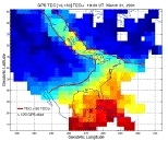
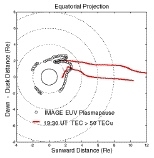
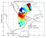
Pairing information gleaned from hundreds of special dual-frequency GPS receivers with data from Haystack's ionospheric radar, researchers at MIT were able for the first time to map the ever-changing plasmasphere from the ground.
In addition to Foster, authors of the GRL paper are Philip J. Erickson, research scientist with Haystack's Atmospheric Sciences Group; Anthea J. Coster, technical staff member at the Lincoln Space Surveillance Complex, MIT Lincoln Laboratory; Jerry Goldstein of Rice University in Houston and Frederick J. Rich of the Air Force Research Laboratory at Hanscom Field, Lexington, Mass.
The researchers say they have achieved a breakthrough in using new methods to study and map the Earth's atmosphere, with results directly applicable to the very young field of space weather prediction.
"The scientific and applications interests overlap," Foster said. "With our GPS maps and the high-altitude NASA imagery, we can construct a global picture of the plasmasphere. Detailed low-altitude radar and satellite observations then guide our interpretation of the physics involved. By putting together multiple views, we can come up with a consistent picture."
HEAVY WEATHER
The Earth is rotating under an ever-changing system of interacting electric and magnetic fields, electric currents and charged particles called the magnetosphere. Ionization of our upper atmosphere by ultraviolet sunlight produces a plasmasphere nearest the Earth. Here, particles are a cold, dense mixture of electrons and ions called a plasma. Based on local conditions, the plasma can be dense with electrons or diffuse.
The magnetosphere provides a barrier to the solar wind, which explodes earthward from the sun's outer atmosphere during violent solar storms. These outbursts result in dramatic changes through the geospace environment.
Plasmaspheric tails - long plumes with increased electron concentrations - can result. Radio waves originating on the ground can move through homogenous areas easily, but the edge of the tails, where low- and high-density areas of electrons collide, is like a brick wall to radio waves.
This disrupts satellite transmissions, but "knowing there is a problem (such as the location of a plasmaspheric tail) allows the user to change to another communications link," Erickson said.
SCANNING THE SKIES
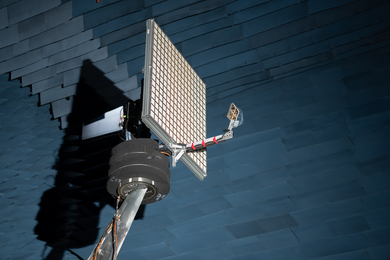
Haystack's Millstone Hill radio antenna in Westford, Mass., looks like a giant metal spider web. Its large size, combined with sensitive receivers and a powerful transmitter, provides researchers with detailed diagnostics of the charged upper atmosphere from the ground. The only system of its kind in the continental United States, it is in a prime location to monitor space weather over eastern North America.
Lincoln Laboratory has been pursuing GPS ionospheric investigations since 1985. Precise knowledge of the ionosphere is critical to accurately track Earth-orbiting satellites.
"These MIT programs provide a unique environment for combining basic and applied research. People doing GPS need to know about the physics, and people doing the physics need GPS to understand what they are seeing," Foster said.
"The research community can now unify disparate things they've seen in one explanation," said Erickson. "That's the real power of this."
This work is funded by the National Science Foundation through a cooperative agreement with MIT and by the U.S. Air Force.