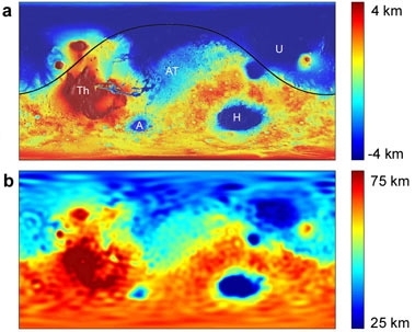
A new analysis of the topography and gravity of Mars by researchers at MIT and NASA has solved one of the biggest remaining mysteries in the solar system -- why the planet Mars has two completely different kinds of terrain, in its northern and southern hemispheres. In the process, they have identified what appears to be by far the largest impact scar found anywhere.
The giant basin that covers about 40 percent of the surface of Mars, sometimes called the Borealis Basin, is actually the remains of a colossal impact very early in the solar system's formation, the new analysis shows. The basin, 8,500 km across and 10,600 km long, is larger than the combined area of Asia, Europe and Australia, and about four times wider than the next-biggest impact basins known, the Hellas basin on Mars and the South Pole-Aitken basin on the moon.
The northern-hemisphere basin on Mars is one of the smoothest surfaces found anywhere in the solar system, and some geologists think it may once have contained an ocean in the early days of the planet. The southern hemisphere is high, rough, heavily-cratered terrain, which ranges from 4 to 8 km higher in elevation than the basin floor. Until now, nobody really knew why the two halves were so different.
The new findings are being reported this week in a paper in the journal Nature by MIT postdoctoral researcher Jeffrey Andrews-Hanna, Maria Zuber, MIT's E.A. Griswold Professor of Geophysics, and Bruce Banerdt of NASA-JPL. Accompanying this analysis of the elevations and gravitation of Mars, which shows clear signs of the impact basin, are two other papers that provide a theoretical analysis of the kind of impact that would have been required to create it.
The mystery of how to explain the two-faced nature of the Martian surface has been perplexing planetary scientists ever since the first comprehensive images of the surface were beamed back to Earth from spacecraft in the late 1970s. For many years, there have been two main alternatives: Either some internal process related to the planet's molten subsurface layers, or an ancient impact.
But the impact idea, originally proposed in 1984 by Steven Squyres of Cornell University, now the lead scientist on the Mars Exploration Rovers project, and Don Wilhelms of the U.S. Geological Survey, had quickly fallen into disfavor because the shape of the basin didn't seem to match the expected round shape for a crater, Andrews-Hanna says. "There wasn't any observational evidence" to support the idea, he says.
Since then, other giant impact basins, including the South Pole-Aitken basin on the moon, have been discovered that are elliptical, rather than circular. But it took a complex analysis of the Martian surface, based on both elevation data and data on its gravitational field gathered by many years of spacecraft observations, to reveal the clear elliptical shape of the Borealis Basin on Mars.
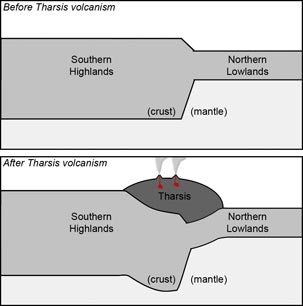
One complicating factor was that since the time of the impact -- which must have been at least 3.9 billion years ago -- giant volcanos have formed along one part of the basin rim, and created a huge region of high, rough terrain that obscures the outlines of the basin. It took a combination of the gravity data from the Mars Reconnaissance Orbiter-- which tends to reveal underlying structure -- with the data on current surface elevations from Mars Global Surveyor, to reconstruct a map of Mars elevations as they existed before the volcanos erupted.
With that reconstruction, a very clear elliptical basin shape emerged, Andrews-Hanna says. The match between a perfect ellipse and the traced boundary line between the two topographic regions was startling. And in addition to the elliptical boundary of the basin, there are also signs along part of the rim of a possible second, outer ring -- a typical characteristic of large impact basins. "An impact is really the only mechanism that can produce these large-scale elliptical depressions, these large holes in the ground," Andrews-Hanna says.
"We haven't proved the giant-impact hypothesis," Andrews-Hanna says, "but I think we've shifted the tide. The majority of the evidence is now in favor of the giant impact."
When he first presented some of these results at planetary science meetings, "since the idea has been unpopular for so long, I expected people to jump on me," he says. "But people have been very receptive."
In fact, both Andrews-Hanna and Zuber, until they carried out this analysis, had been believers in the alternative theory. "I can't believe I'm involved in this," says Zuber, who is head of MIT's department of Earth, Atmospheric and Planetary Sciences. "I've been a supporter of the internal models for years." But when the evidence from the surface reconstruction became clear, she says, they had to go where the data led. "We thought, people aren't going to buy this, but you've got to say what you've got to say."
And in fact, she says, the peer-reviewers of the paper "were very positive, very constructive, they commented about how careful we were."
And identifying this huge scar of an ancient impact, she says, "is pretty exciting." Until now, nobody had clearly identified signs of any ancient impact in that size range. There are one or two even larger impacts thought to have occurred in the early solar system, a controversial theory that there was one on the innermost planet Mercury, and a widely accepted one that the Earth was struck by a planet as big as Mars, melting the crust and ejecting it into space where some of it clumped together to form our moon.
But in both of those cases, the impacts were so enormous that they completely obliterated all visible signs of the event. It is only through indirect analysis, including study of rocks brought back from the moon by the Apollo astronauts, that these giant ancient impacts have been reconstructed. In terms of impacts that left visible basins, the largest known were the Hellas basin on Mars (about 2,400 by 1,800 km) and the moon's South Pole-Aitken basin (about 2,100 by 1,500 km).
"We knew there must be impacts between these size ranges," Zuber says. "But nobody had identified one." Analysis in the theoretical papers accompanying this one show that the impacting object that produced the huge basin on Mars must have been about 2,000 km across - larger than Pluto -- and struck at an angle of about 45 degrees, creating the oval shape of the basin.
The new finding adds yet another major event to the growing list of large impacts that have been recognized over the last few decades as having shaped the planets and moons of the solar system as we know them today. "The early solar system was a very dangerous place to be a planet," Andrews-Hanna says. "But without those impacts, we wouldn't have the planets as we know them today."
The work was supported by a grant from the Mars Reconnaissance Orbiter project at NASA.


