A new landscape erosion model created by MIT researchers includes the significant effects of vegetation on the Earth's surface. They presented the work, titled "Modeling the Influence of Vegetative Dynamics on Landscape Erosion," at the spring meeting of the American Geophysical Union (AGU) in Boston on June 1.
In China, erosion is recognized as the country's most serious environmental problem. Part of the effort to halt annual soil loss in that country, estimated at 5 billion tons a year, involves importing grass seed from the United States.
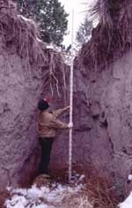
In Italy, repeated landslides in the central and southern Apennines shape the landscape. In the Colorado high plains, gully and arroyo erosion is controlled by vegetative root mats. Strategically placed vegetation can counter erosion and stabilize geographic regions.
SHAPING THE CHANGING LANDSCAPE
MIT researchers have created a model that simulates erosion and sedimentation in a river basin over years, centuries, millennia or longer. Called the Channel-Hillslope Integrated Landscape Development (CHILD) model, it now incorporates features such as the erosion mitigation effects of vegetation.
"It is inevitable for models of landscape evolution to include the effects of vegetation to better understand the processes and rates governing landscape change and development," said Professor Rafael L. Bras, head of civil and environmental engineering and holder of the Bacardi-Stockholm Water Foundation Chair.
In the long term, the landscape is the result of the interaction of soil, climate, geology and vegetation. The interaction is highly nonlinear and active. For example, erosion impacts drainage patterns, which in turn impact soil and vegetation, which impact climate and runoff, which impact erosion again.
In the short term, a landscape erosion model that incorporates the effects of vegetation can be used as a land management tool. "Tools like this help plan how to manage eroding land, and explore whether proposed solutions will hold up," Professor Bras said.
In addition to Professor Bras, the research team includes Daniel Collins, a graduate student in civil and environmental engineering; former postdoctoral associate Gregory Tucker, now a professor at Oxford University in England; Dr. Vanessa Teles, a postdoctoral associate; and Nicole Gasparini (SM 1998).
MODELING GLOBAL LANDSCAPES
The challenge for researchers is to interpret the history of landscapes from existing drainage and vegetation patterns, as well as to predict how landscapes will evolve in the future.
A powerful method for interpreting global landscapes is to create a numerical model of complex earth systems. Such models help researchers develop insight and generate testable predictions.
Several landscape evolution models have been created during the past decade, but vegetation has not played a big part in models of this type. They have included what Professor Bras calls "passive" effects of vegetation, not the dynamic reality of the living system.
Vegetation grows, dies, is swept away in storms and reestablishes itself. It follows moisture, and in turn influences the soil's moisture and its ability to erode. Because it is constantly changing, it is difficult to incorporate in a model.
The CHILD model "mimics the interaction of soil, geology, climate and now vegetation. We can reproduce what we observe in nature through a mechanism that people had not previously thought of. The model has challenged existing interpretations of data because it may produce facts that don't quite fit the current picture," Professor Bras said.
"A paleoclimatologist looking at certain phenomena might say that a certain landscape characteristic came about because of this or that, but the model may point to a completely different reason not previously considered. I think the model is very powerful as a benchtop virtual laboratory to investigate the dynamic behavior of landscapes," he said.
A related issue that may be better understood through the new CHILD model is undersea formations. Created by density currents, someof these formations have drainage systems just like those on the Earth's surface. A tool that helps interpret those areas would be of great value to oil companies and others who work on the ocean floor.
A version of this article appeared in MIT Tech Talk on June 6, 2001.


