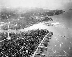
The name of the book is "Cities From the Sky: An Aerial Portrait of America." Its 125 photographs document the evolution of the major cities of the United States, taken over 40 years for Fairchild Aerial Surveys Inc.
The book was completed before Sept. 11, 2001.
"Definitely, the relationship between cities and the airplane was made toxic on that day," author Thomas J. Campanella (Ph.D. 1998) said before a lecture and slide show last Thursday in Edgerton Hall entitled "The Camera, the Airplane and the City," which celebrated the book's publication by Princeton Architectural Press.
Television cameras and still photographers recorded for posterity the awful images of airliners purposely crashing into New York's Twin Towers on Sept. 11. "The airplane itself as a weapon was burned into our imagination forever," said Campanella, a lecturer in city design and development in the Department of Urban Studies and a columnist for Wired magazine.
In his lecture, Campanella, a licensed pilot, described altitude as "the muse of enlightenment," allowing human beings to gain perspective on their world. People climbed towers and hills before flight was possible, then soared on manned kites, balloons, dirigibles and airplanes. The airplane was the key to perspective in modern times, he said, becoming "fused with millennial dreams of a Machine Age utopia."
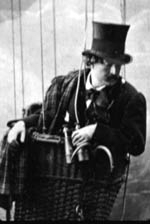
Campanella said the first aerial photographs were taken by a French portrait photographer (his models included Baudelaire, Balzac, Rossini and Monet) named Nadar, founder of the Society for the Encouragement of Aerial Locomotion, whose members included author Jules Verne and composer Jacques Offenbach. Nadar snapped pictures of a village near Paris from a tethered balloon hovering at 250 feet in 1858 and the Arche de Triomphe from 1,700 feet 10 years later.
In 1909, Campanella said, Charles Lambert, Wilbur Wright's first student, flew a plane over and around the Eiffel Tower during the first flight over a city. Le Corbusier, then an architecture student, watched from the ground and never forgot. "The airplane carries our hearts above mediocre things," he wrote in a 1935 book entitled "Aircraft."
"While the clean lines and pure functionality of the flying machine certainly thrilled him, it was the unprecedented view of the built city it made possible that Corbusier found most exciting--and most troubling," Campanella said. ������
Quoting from "Aircraft," Campanella continued: "'It is as an architect and town planner--and therefore as a man essentially occupied with the welfare of his species--that I [Corbusier] let myself be carried off on the wings of an airplane, make use of the bird's-eye view, of the view from the air, to which end I directed the pilot to steer over cities.'"
Shocked, Corbusier continued: "The airplane eye, reveals a spectacle of collapse ... Cities, with their misery, must be torn down. They must be largely destroyed and fresh cities built."
Within a few years, airplanes were the agents of the destruction of cities, among them London, Nanking, Dresden and Hiroshima. After the war, aerial photography was used in the rebuilding and renewal process. This led to a role in city planning, but not always with positive results.
"While aerial photography served as the handmaiden to urban renewal projects in the 1950s and 1960s, it also inadvertently documented for posterity much of the urban fabric that was lost or in the process of convulsive transformation," Campanella said.
Images in the sllde show included an illustration of the destruction of New York from H.G. Wells' novel "The War in the Air," written in 1908. "The resemblance between this scene of destruction and the wreckage of the WTC is haunting," Campanella said.
The lecture, part of the authors@mit series, was co-sponsored by the MIT Libraries and the MIT Press Bookstore.
A version of this article appeared in MIT Tech Talk on November 14, 2001.


