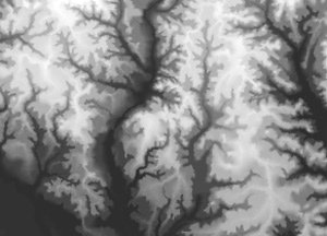
ATLANTA -- From the air, riverbed erosion might look like limbs branching off a tree trunk, crystals forming on an icy windowpane, a fern's spiky leaves or a nerve cell's axons. Even tiny sections of the complex and beautiful patterns of landscape erosion mimic the whole, adding intrigue to the fiendishly difficult task of unraveling its physics.
Daniel Rothman, professor of Earth, Atmospheric and Planetary Sciences, and his research team at the Massachusetts Institute of Technology will report today (March 23) in an invited lecture at the centennial meeting of the American Physical Society that they are making headway with this challenge. Rothman and his team use a combination of physical reasoning, analysis of digital elevation maps and computer simulation to predict and describe the mechanics of water-driven landscape erosion.
The talk will be part of a 10:30 a.m. session at the Georgia World Conference Center on physics in the petroleum industry.
The researchers' goal is to explain why a landscape exhibits its particular features, and why so many landscapes, whether the underwater continental slope off the coast of Oregon or the Amazon River basin, exhibit similar features. Their work may make it easier to find oil, predict floods and even figure out if a landscape on Mars was sculpted by running water.
Whether you're looking at the Kentucky River or the Appalachian plateau in northwest Pennsylvania, geologic surfaces show a certain degree of universality. And civilization's huge imprint on our planet hasn't affected the large-scale features like mountain ranges or continent-spanning river basins that Rothman studies.
"Based on simple assumptions concerning the tendency of running water to run in the same direction -- in other words, inertia -- our model challenges existing theories of landscape evolution that assume landscapes evolve to a form that minimizes the rate of energy dissipation," said Rothman, a geophysicist whose areas of research include fluid mechanics and nonlinear dynamics.
The task of Rothman, MIT graduate students Peter Dodds, Kelvin Chan and postdoctoral fellow Romualdo Pastor-Satorras is akin to reconstructing a crime scene. The clues the researchers use are based on physical properties, geophysical reasoning and mathematical insight.
Rain falls and fluids seep out from under the surface of the land. Avalanches change the pattern of erosion and add sediment. To make the task even more challenging, shifting tectonic plates can tilt the whole scene so it's unclear which direction is up.
Even though researchers don't know exactly what soil and water and weather will do over time, they do know, for instance, that water and sediment will move mostly downhill and that the whole scene, which could cover thousands of square miles or more, will end up forming a rather symmetrical pattern.
These patterns can help provide greater understanding of all river network laws, which in turn can be applied to networks of almost any kind. "We are intrigued by recent studies of biological networks and are finding that our work may have an impact in this area as well," Dodds said.
Using mountains of measurement data from digital elevation maps of landscapes, the researchers' goal is to make mathematical sense of the dendritic patterns of the river's branches and its tiny tributaries. Incorporating existing knowledge of the fractal nature of rivers, one problem researchers face is to explain the structure of river networks, such as those that describe distribution of stream lengths, basin size and the overall dendritic morphology itself.
"Scaling laws are useful for extrapolating the mathematical relationships between the various known quantities into unexplored regimes," Rothman said. "We view the problem of topography by investigating the statistical properties of surfaces. The imprint on topography can be measured, and direction of flow can be measured. Features that are indiscernible by the eye can be mathematically measured.
"We've gained some understanding of how the local structure of river networks depends on global construction of the topography," Rothman said "We're looking for general principles that will apply to any landscape. After all, the same physical mechanisms are at play. Even though every landscape is different, they all contain some features in common."
Rothman points out that this is an exciting time in the field. Within one to two years, NASA promises to provide the fruits of the Shuttle Radar Topography Mission -- digital topographical maps of most of the surface of the planet with a horizontal resolution of 30 meters. Such a huge amount of accurate data helps the work of the theorist, he said, by providing a huge backup against which to test your work. Often, he says, "what doesn't work is even more exciting than what does."
This work is supported by the National Science Foundation.


