Measurements by an instrument orbiting aboard NASA's Mars Global Surveyor spacecraft have provided striking new views of the north pole of the red planet and the processes that have shaped it.
This first three-dimensional picture of Mars' north pole enables scientists to estimate the volume of its water ice cap with unprecedented precision, and to study its surface variations and the heights of clouds in the region for the first time.
The work will be reported by a team of 21 scientists in the December 11 issue of Science. Five of those scientists, including first author Maria T. Zuber, are from MIT. Professor Zuber, of the Department of Earth, Atmospheric and Planetary Sciences (EAPS), also presented a talk on the work at a December 6 meeting of the American Geophysical Union.
"We've improved our knowledge of the amount of frozen surface water on Mars by at least two orders of magnitude," said Dr. Zuber, discussing the importance of the new measurements.
The work also gives new insights to how water reached the planet's north pole. "In the past, researchers thought that the polar caps occurred solely as a result of water condensing out of the atmosphere," Professor Zuber explained. "Although condensation undoubtedly still plays an important role, we've now established that there was also a land route." The researchers found that earlier in Mars's history, when the planet was still warm enough to support liquid water, that water "flowed through outflow channels near the equator to the pole."
New observations concerning the clouds on Mars included the first measurements of cloud heights. In addition, "we observed that the clouds have a dynamical structure," Professor Zuber said. That structure is probably caused by winds interacting with surface topography, much as occurs on Earth when winds collide with mountains to produce turbulence. "We also observed carbon dioxide condensing out of the atmosphere" to form the clouds, she said. She noted that the latter work was conducted by Professor Emeritus Gordon H. Pettengill of EAPS.
MIT authors of the Science paper are Professors Zuber and Pettengill; Peter G. Ford, a principal research scientist at the Center for Space Research; Gregory A. Neumann, an EAPS research scientist; and Oded Aharonson, an EAPS graduate student. Other authors were from NASA's Goddard Space Flight Center, the California Institute of Technology, Brown, the Carnegie Institution, Washington University and the Jet Propulsion Laboratory.
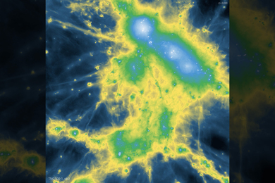
MOLA MEASUREMENTS
The elevation measurements were collected by the Mars Orbiter Laser Altimeter (MOLA) aboard Global Surveyor during the spring and summer of 1998 as the spacecraft orbited Mars. MOLA sends laser pulses toward the planet and measures the precise amount of time before the reflected signals are received back at the instrument. From this time, scientists can infer surface and cloud heights. Approximately 2.6 million of these laser pulses were assembled into a topographic grid of the north pole with a spatial resolution of 0.6 miles and a vertical accuracy of 15-90 feet.
The topographic map reveals that the ice cap is about 750 miles across, with a maximum thickness of 1.8 miles. The cap is cut by canyons and troughs that plunge to as deep as 0.6 miles beneath the surface. "Similar features do not occur on any glacial or polar terrain on Earth," said Professor Zuber, who is also affiliated with NASA-Goddard. "They appear to be carved by wind and evaporation of ice."
The MOLA data also reveal that large areas of the ice cap are extremely smooth, with elevations that vary by only a few feet over many miles. In some areas the ice cap is surrounded by large mounds of ice that are tens of miles across and up to half a mile in height. "These structures appear to be remnants of the cap from a time when it was larger than at present," Professor Zuber said. Impact craters surrounding the cap were seen to be filled with ice and dust that were either deposited by wind or condensation, or perhaps remain from an earlier period when the ice cap was larger.
The shape of the polar cap indicates that it is composed primarily of water ice, with a volume of 300,000 cubic miles. The cap covers an area 1.5 times the size of Texas. For comparison, the volume of the Martian north polar cap is less than half that of the Greenland ice cap and about 4 percent of the Antarctic ice sheet.
The estimated volume of the north ice cap is about 10 times less than the minimum volume of an ancient ocean that some scientists believe once existed on Mars. If a large body of water once existed on the red planet, the remainder of the water must now be stored below the surface, within the much smaller south polar cap, or has been lost to space. But such a large amount of unaccounted-for water is not easily explained by current models of Martian evolution.
During its mapping of the north polar cap, MOLA also made the first direct measurement of cloud heights on the red planet. Reflections from the atmosphere were obtained at altitudes from just above the surface to more than nine miles on about 80 percent of the laser profiles. Most clouds were observed at high latitudes, at the boundary of the ice cap and surrounding terrain.
MOLA is not now collecting data because the Global Surveyor spacecraft is aerobraking through the Martian atmosphere in order to achieve its intended 250-mile altitude circular mapping orbit. MOLA observations will begin again in March 1999 when the spacecraft begins its two-year mapping mission, which will provide global coverage of Mars and observations of seasonal changes by the spacecraft's full suite of instruments.
The principal investigator for MOLA is Dr. David E. Smith of NASA-Goddard; Professor Zuber is deputy principal investigator. Further information about MOLA and images created from its measurements of the north pole are available on a NASA-Goddard web site.
A version of this article appeared in MIT Tech Talk on December 9, 1998.