If you’ve ever turned down a city street only to be blasted with air, you’ve stepped into what is known as an urban canyon.
Much like their geological counterparts, urban canyons are gaps between two tall surfaces — in this case, buildings. The gusts they channel, however, have real implications. They can magnify a hurricane’s winds or increase a city’s air temperature depending on their arrangement — an arrangement known as city texture. The problem is, according to researchers at the MIT Concrete Sustainability Hub (CSHub), that current hazard mitigation practices don’t consider city texture. Consequently, they frequently underestimate damages, in some cases by as much as a factor of three.
Reconsidering current practices
To understand the potential impact of city texture, CSHub researchers first investigated the current construction practices. One of the practices they examined were building codes.
According to the Federal Emergency Management Agency, “Building codes are sets of regulations governing the design, construction, alteration, and maintenance of structures.” One of their purposes is to protect the inhabitants of a building from natural disasters by specifying the strength of that building.
To keep buildings safe from wind hazards, codes stipulate how a building must interact with the wind, a value known as a drag coefficient. The drag coefficient of a building determines the amount of air resistance it will experience when exposed to the wind. As a building’s drag coefficient increases, so does its likelihood of damage.
“Design codes assume that buildings have fixed drag coefficients. And in a way, that makes sense — the shape of a building doesn’t change much,” says Jake Roxon, a researcher at CSHub. “However, we’ve found that it’s not just the shape of the building that affects its drag coefficient, but also the local configuration of adjacent buildings, which we refer to as urban texture.”
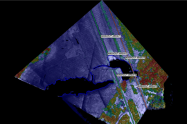
Urban texture measures the probability of finding a neighboring building at a certain distance away from a given building. Roxon calculates it by drawing rings of a certain diameter around each building in a city. Then he counts the number of buildings in each ring.
The more buildings in each ring, the greater the probability is of finding a building at that distance. And the higher the probability, the more ordered and regular the local texture is, while the lower the probability, the more disordered and unpredictable. To capture a whole city’s texture, Roxon averages together the texture of each of its buildings.
“On average, we have found that areas with disordered textures have more resilience,” says Roxon. “If you are unable to predict which angle the wind will come from, it will offer the greatest level of protection. On the other hand, for an ordered city with the same density of buildings, you would expect to see more damage during an extreme hazard event.”
The reason behind the resilience of disordered streets is how they distribute wind. By distributing wind more randomly, disordered cities like Boston or Paris experience less of the magnification that occurs as the wind travels the corridors of ordered cities, such as New York. In some cases, cities with more ordered textures can magnify hurricane winds from a Category 3 to a Category 4, Roxon has found.
The impact of city texture on drag coefficients and wind loads appeared prominently during Hurricane Irma in 2017, which passed through West Florida.
“An example of the texture effect is Sarasota and Lee counties in Florida during Irma,” explains Ipek Bensu Manav, a CSHub researcher collaborating with Roxon. “Those counties are situated close to each other geographically, so they experience a similar hurricane risk. And when you look at the building stocks, they are also similar — mostly single and two-floor single-family houses.”
However, the two counties differed in terms of texture.
“Sarasota County has a less-ordered texture, falling less onto a typical grid, and Lee County has a more orderly texture,” says Manav. “When looking at Lee County we saw more structural damage — some buildings collapsed completely. There were more flooding and overturning of vegetation as well. So, Irma caused a lot more damage in the county that had a higher texture effect.”
It turns out, too, that ordered textures have a similar effect on heat.
“We have found this to be the case with temperature as well — specifically, the urban heat island effect,” says Roxon. “Ordered cities experience the greatest temperature difference between them and their rural surroundings at night.”
Code cracking
So, then, if layouts of streets greatly influence hazard damage, why don’t building codes account for them?
Simply put, it’s currently too difficult to incorporate them.
Right now, the standard tool for investigating the drag coefficients of a building is computational fluid dynamics (CFD). CFD simulations measure the drag coefficient of a building and its hazard risk by modeling the flow of heat and wind. Though highly accurate, CFD simulations demand prohibitively intense time and computing requirements at scale.
“Using current resources, CFD simulations simply don’t work on the scale of cities,” says Roxon. “New York City, for example, has over 1 million buildings. Running a simulation would take a long time. And if you make just one small adjustment to the arrangement of buildings or the direction of the wind, you have to rerun the simulation.”
Despite their imperfections, CFD simulations remain an important tool for understanding wind flow. But Roxon believes his city texture model can compensate for CFD’s limitations and, in the process, make cities more resilient.
“We have found that there are certain variables derived from city texture that allow us, with relative accuracy, to estimate the drag coefficients for buildings and identify areas vulnerable to risks of damage. Then we can run CFD simulations to determine precisely where that damage will occur.”
Essentially, city texture serves as a first-line tool for stakeholders, allowing them to assess risk and then use their resources, including CFD, more efficiently to identify vulnerable buildings for retrofit and, in turn, save lives.
The complete picture
In addition to the loss of life, natural disasters inflict an immense financial toll. According to the National Oceanographic and Atmospheric Administration, 258 natural disasters have caused more than $1.75 trillion of damage in the United States since 1980.
While numerous practices can predict and mitigate these costs, Manav has found that they still leave a lot on the table — namely, city texture.
By collaborating with Roxon, she has discovered that by discounting community characteristics like city texture, current models underestimate losses, often dramatically.
To apply texture to hurricane losses, Manav looked once again to Florida’s Sarasota and Lee counties. She conducted a conventional loss estimation and a city texture-adjusted loss estimation for each county based on the 95th percentile of annual expected hazard events — equivalent to some of the strongest hurricanes, like Irma. She found that the expected losses increased when she incorporated city texture into her estimations. The increase was particularly acute in Lee County, whose ordered texture would likely magnify wind loads.
“In Sarasota County, we saw an increase in the expected loss from 1 percent to 6 percent of average home’s value when incorporating city texture,” says Manav. “But doing the same for Lee County, we saw an appreciably higher amount of damage, equivalent to approximately 9 percent of an average home’s value.”
Without incorporating city texture, then, these conventional estimations dramatically underestimate damages. This makes residents unaware of their hazard risk, and consequentially leaves them vulnerable.
The incentives for resilience
As sobering as these loss estimations are, Manav hopes they may yet help communities become more hazard-resilient.
Currently, she notes, hazard resilience has not become broadly implemented because most remain unaware of its cost benefits.
“One reason hazard-mitigation practices are not being implemented is that their benefits are not being communicated thoroughly,” she says. “Obviously, there is the cost of constructing to better standards. But to balance out these costs there are the benefits of reduced repair costs following hazard events.”
These reduced damage costs are significant.
Actions as simple as choosing hardier shingles, improving roof-to-wall connections, and adding shutters and impact-rated windows can mitigate hazard damages enough to pay back in as little as two years in hazard-prone areas like coastal Florida.
By using city texture to calculate hazard costs, Manav and Roxon hope homeowners, developers, and policymakers will choose to implement these relatively simple practices. The only key is making their incentives widely known.