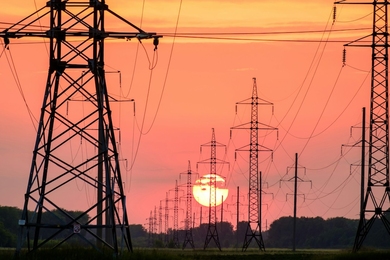
Hurricane Florence's slow trot over North and South Carolina in September led to inundating rain, record storm surges, and another major disaster for the Federal Emergency Management Agency (FEMA) to contend with. Facing damage over hundreds of square miles, FEMA again called upon MIT Lincoln Laboratory to use their state-of-the-art lidar system to image the destruction in the region.
Installed onto an airplane and flown nightly over a disaster site, lidar (which stands for light detection and ranging) sends out pulses of laser light that bounce off the land and structures below and are collected again by the instrument. The timing of each light pulse's return to the instrument is used to build what researchers call a "point-cloud map," a high-resolution 3-D model of the scanned area that depicts the heights of structures and landscape features. Laboratory analysts can then process this point-cloud data to glean information that helps FEMA focus their recovery efforts — for example, by estimating the number of collapsed houses in an area, the volume of debris piles, and the reach of flood waters.
Yet quickly sending the nearly two terabytes of data from a single night's scan, or sortie, to the Laboratory for processing is a challenge. After a storm, local internet connections may be gone or spotty. When the Laboratory used this same lidar platform after Hurricane Maria in Puerto Rico, downed networks meant having to physically ship a hard drive back to Massachusetts — a more than two-day delay in getting the data into analysts' hands. When the team started the campaign in the Carolinas in mid-September, they faced the same obstacle.
This time, the obstacle was hurdled thanks to MCNC. The nonprofit organization formerly known as the Microelectronics Center of North Carolina is based out of Research Triangle Park near Durham, North Carolina, which was not directly affected by Hurricane Florence. MCNC gave the Laboratory free access to their North Carolina Research and Education Network (NCREN).
"Our state was hit hard by Hurricane Florence," says Tommy Jacobson, MCNC's chief operating officer and vice president. "For MCNC's leadership, it was a quick and easy decision to enable MIT, who was in the state to assist FEMA, with access to our network resources to help however we could in making sure relief got to those that needed it."
NCREN is North Carolina's broadband backbone, connecting more than 750 institutions including all public school districts in the state, universities and colleges, public safety locations, and other community anchor institutions. Access for the Laboratory meant rack space for equipment inside the MCNC data center. From there, MCNC provisioned a 10-gigabit IP connection from the NCREN to Internet2, an ultrafast, advanced network that connects research centers around the world. This connection gave the team the ability to upload large volumes of data daily from their equipment inside the data center back to a computing center on MIT campus that is also connected to Internet2.
From there, another 10-gigabit connection bounced the data from campus to the Lincoln Laboratory Supercomputing Center in Holyoke, where the data were processed.
"The 10-gig uplink from MCNC allowed us to transmit the data at such a higher speed that some of our uploads were done in about six to seven hours," says Daniel Ribeirinha-Braga, a member of the Laboratory's data management team in this hurricane effort. "Keep in mind that this is lidar data, which we get about 1.5 to 1.9 terabytes a night of, that needs to be copied to multiple places, such as other hard drives, organized to a single SSD [solid-state drive], and then uploaded to the Laboratory from MCNC."
The collaboration between the Laboratory and MCNC came about through Matt Daggett, a staff member in the Humanitarian Assistance and Disaster Relief (HADR) Systems Group. He had worked at MCNC more than a decade ago.
"I was aware of the NCREN backbone and the data center on the MCNC campus," Daggett says. "When it became clear that our flight operations would be based out of the RDU [Raleigh–Durham International] airport, I knew MCNC would be the perfect place to get our data onto the Internet2."
Adds Jacobson: "We were grateful that MIT sought us out to provide that help,"
With the data processing underway, the Laboratory has begun delivering reports to FEMA. The lidar imagery reveals things that would be impossible for FEMA to know from looking only at satellite images. "The most important difference between a satellite image and the lidar image is that you can do 3-D measurements on it," says Anthony Lapadula of the HADR Systems Group. "So, because it's 3-D data, we can do things like tell you how big a hole in a road is, or tell you how big an elevation drop is as a result of a landslide."
One of the greatest advantages of the lidar work has been the time saved for FEMA. When someone reported damage at a specific location, FEMA could assess the damage quickly by asking Laboratory analysts to virtually visit the location in the point-cloud map and report what they found.
For instance, FEMA asked them to zoom in on a small town on the Lumber River in North Carolina that had been inundated with flood waters. Analysis of the data told FEMA the extent of the flood inundation, the volume of debris piles in the town, and changes in the river's path. There were also environment questions to be answered, such as what the volume was of a coal ash pile to determine how much, if any, washed away with flood waters. They could also check in on public infrastructure, like a lock and dam along the Cape Fear River that the data showed to be completely flooded.
Completing the 40 sorties requested over the Carolinas took the team several weeks to complete, right up until Thanksgiving. The sorties covered areas down the coastline from the Cape Lookout National Seashore to Myrtle Beach and through bands stretching inland. These hundreds of miles of lidar data were processed to a resolution of approximately 25 centimeters. To put that resolution into perspective, Lapadula says that if the scanned areas were covered completely with basketballs, they would be able to precisely measure the location of each ball.
But with only one of these extremely advanced systems available for use, Lincoln Laboratory staff are limited in how much area they can cover and how many disasters they can respond to with the technology. The lidar system was originally developed by the Active Optical Systems Group, who has been assisting the HADR Systems Group with data collection, processing, and algorithm development.
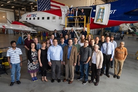
Several industry collaborators also participated in this effort. Employees from the small business 3DEO, which specializes in Geiger-mode lidar technology, assisted with the data collection. The small business LEEP has been helping with data analytics and providing training to FEMA analysts to facilitate the use of the data. Another partner, Basler Turbo Conversions, supported engineering aspects of installing the lidar on the BT-67 aircraft, which is being leased from the company AIRtec.
While the laboratory has been involved in disaster recovery since the 2010 Haiti earthquake, it has never been so active in these efforts as in the past year since Hurricanes Harvey, Irma, and Maria in 2017.
"We went a decade without a major hurricane hitting the continental United States," Lapadula reflected. "Now, it's like they just keep coming."