Most cities in the developing world rely on informal networks of minivans and buses to bring laborers to work and goods to market. Yet little information or data are available about these networks, where bus stops can change by the minute and fares can quadruple when it rains. In cities from Bogotá to Addis Ababa, commuters and suppliers can only find their way through word of mouth. And these informal but essential networks are almost invisible to planners who pilot urban expansion and development.
Now this may change, thanks to Digital Matatus, a novel research project in Nairobi, Kenya. A joint effort involving MIT, Columbia University, the University of Nairobi, and Groupshot Design Consultancy, Digital Matatus deployed Kenyan researchers equipped with smartphones to collect and analyze data from the network of matatus — privately owned minivans — that services the Kenyan capital.
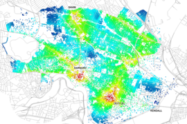
The open-source data, which were initially transformed into a popular paper map, are now searchable in Google Maps as a transit option, making it possible for anyone with a smartphone to navigate the city using a matatu.
“Roughly 3.5 million people depend on matatus every day in Nairobi but have little information on the more than 130 different routes. Providing this information via Google Maps not only increases accessibility to the transit system, but also serves as a model for how to create information on public transport for cities across Africa where people depend on matatu-like transit systems. Perhaps more importantly, this essential data is now available for transportation planning initiatives in a city that struggles with congestion,” says Sarah Williams, an assistant professor of information technology and urban planning at MIT whose team developed the data-collection strategy, transferred the data to GTFS (which allowed the data to be included in Google), and the created the stylized transit map that has become very popular in Nairobi.
Informal transportation systems are often the main transit option for most commuters and residents, but they can seem chaotic, with many different operators independently creating routes and setting pick-up and drop-off times. As a result, urban planners and policy makers in these cities tend to ignore the systems, finding them hard to regulate and manage. “Before, the biggest excuse for not considering these informal systems in planning was a lack of data,” says Jacqueline Klopp, a research scholar at Columbia University’s Center for Sustainable Urban Development and the principal investigator on Digital Matatus. “Now we have that data.”
Supported by a grant from The Rockefeller Foundation, the Digital Matatus project was conceived at Columbia University, where Williams worked as director of the Spatial Information Design Laboratory through August 2012, when she moved to MIT. Klopp reached out to colleagues at the University of Nairobi, in the Kenyan government, and at UN Habitat and The World Bank. Williams worked with her laboratory to determine how the collected data would be analyzed and rendered. Their mutual colleague Adam White, founder of Groupshot, sounded out the burgeoning Nairobi tech community for coders who could eventually develop apps around the Digital Matatus data.
“One of the reasons this project succeeded is that it was an equal partnership between institutions,” White says. “The majority of the groundwork was done by Kenyans. And we didn’t just drop in overnight. We spent a lot of time reaching out to various stakeholders so they would support the project. Right now, our data is being used by five apps in Nairobi.”
Data collection commenced in February 2013, when a student team from the University of Nairobi led by Dan Orwa and Peter Wagacha began using cellphones to collect data on the previously inscrutable matatu network. In all, the team charted over 3,000 matatu stops, most of which had been established by private matatu drivers, not the local government.
The work required a certain agility: Nairobi has multiple cellular networks, requiring users to switch SIM cards as they cross from one coverage zone to another. Some fellow matatu passengers looked at them with suspicion, and at least one phone was stolen. The constant pinging of latitude and longitude drained researchers cellphone batteries quickly.
Rendering the data also required some creativity. The General Transit Feed Specification (GTFS) format that Google uses for public transportation schedules works beautifully in mapping formal transportation systems. But several key data points in Nairobi’s informal system were unavailable, including regular fares and operating schedules. Williams and her laboratory colleagues worked with a wide group of transit specialists to produce a modified GTFS standard flexible enough for Nairobi’s informal system while still robust enough for Google.
In January 2014, Digital Matatus released a stylized transport system map resembling subway maps from developed world capitals like London, New York, and Paris. The map was wildly popular, with over 5,000 downloads registered in the first six months. One local startup tied its advertising strategy to the matatu data.
“We believe that visualization, such as the map we developed, is essential for making policy,” says Williams, who also directs the Civic Data Design Laboratory at MIT. “The data was available long before we released the map. But people only got excited about using the data only after we released the stylized transit map that looked like something they would see in New York or London. Big data alone is not going to change the world. It’s how you synthesize it into tools that can be used by communities.”
While pleased to have set a precedent with Google Maps, the Digital Matatus team hopes that their research will eventually influence policy as cities like Nairobi develop and expand. “Development tends to ignore public transportation,” Klopp says. “We can make these new cities more equitable and cleaner if we focus more on public transport. And making these informal systems visible is a critical first step.”