According to Craig Martin, deciphering Earth’s geologic past is like an ant climbing over a car crash. “You’ve got to work out how the car crash happened, how fast the cars were going, at what angle they impacted,” explains Martin, a graduate student at MIT’s Department of Earth, Atmospheric and Planetary Sciences (EAPS). “You’re just a tiny ant wandering over this massive chaos,” he adds.
The crash site Martin is investigating is the Himalayas, a 1,400-mile mountain range that rose when the Indian and Eurasian tectonic plates scrunched together. “The mainstream idea is: There was Eurasia; there was India; and they collided 50 million years ago,” says Oliver Jagoutz, an associate professor in EAPS and Martin’s advisor. “We think it was much more complicated than that, because it’s always more complicated.”
Detective work at 11,000 feet
Eighty million years ago, India and Eurasia were 4,000 miles apart, separated by an ancient body of water that geologists call the Neotethys Ocean, but Jagoutz believes there was more than just seawater between the two. He’s not alone. Many geologists agree on the existence of an arc of volcanic islands that formed on the boundary of a smaller tectonic plate, similar to the Mariana Islands in the Pacific Ocean. However, there is debate on whether these islands first collided with the Eurasian plate to the north or the Indian plate to the south. Jagoutz’s hypothesis is the latter. “If I’m right, the arc sits near the equator. If the others are right, the fragments should be 20 degrees north,” he explains. “That’s how simple it is.” But it can mean a world of difference in terms of explaining the paleoclimate — not just in the Himalayas, but globally as well.
To test this hypothesis, Jagoutz and Martin turned to paleomagnetism. Some rock minerals, such as magnetite, contain iron and act as tiny bar magnets, orienting their magnetization along Earth’s magnetic field. At the Equator, magnetite in newly formed rocks will be magnetized parallel to the ground but the further north or south it is, the more inclined the magnetization will be. “We can measure, essentially, the latitude that a rock was formed at,” explains Martin.
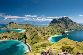
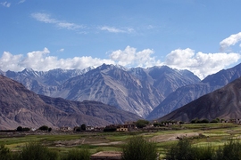
If you were to take a slice of the Kohistan-Ladakh region of the Himalayas in northern India, you would see a succession of rock layers representing the India plate and the Eurasia plate, with the volcanic island arc sandwiched in between. “That’s why Ladakh is a really cool place to go to, because you can walk though this whole collision,” says Martin.
In summer 2018, Martin and Jade Fischer, a junior double-majoring in EAPS and physics, spent six weeks in Ladakh collecting samples from the volcanic rocks. Back at MIT, Martin measured the paleomagnetic signature of these rocks, and his results placed the Kohistan-Ladakh arc right at the equator, in agreement with Jagoutz’s theory.
A magnetic collaboration
Megan Guenther, a junior in EAPS, first heard about the opportunity to do field work in Ladakh when Martin gave a presentation about his research in her structural geology class last fall. “At the end, he told us he was probably going again and to let him know if we were interested,” Guenther explains. “I emailed him an hour later.”
Guenther had been looking for a chance to gain more field experience. She works on the compositions of lunar glasses with Tim Grove, the Robert R. Shrock Professor of Earth and Planetary Sciences, where the research takes place entirely in the lab. “You can’t really do field work on the moon,” she jokes.
This past summer, Guenther and Martin spent six weeks in Ladakh collecting rock samples from the Eurasian plate to prove that this was not also further south, mapping the region and doing structural analyses. Both Guenther and Martin were supported by MIT International Science and Technology Initiatives (MISTI) and the MISTI Global Seed Fund.
MISTI and Jagoutz go back a long time, with MISTI funding class excursions, department field trips, and a number of Jagoutz’s students. “MISTI-India has been good to us,” he says. “They financed the workshop where we came up with the whole concept of this work.” And, says Jagoutz, the students really love the experience. “They get influenced by it, and a lot of people chose their career paths after it,” says Jagoutz. “Ultimately, that’s what MISTI is all about: an experience that tells students they want to get into science.”
For Guenther, the trip was an essential part of her education as a geologist. “I feel much more confident as a field geologist, which is exactly what I wanted,” she says. It also impressed on her the titanic scale of geology. “The scale of everything is so crazy,” says Guenther. “You’re already at 11,000 feet, minimum, the whole time, and then these huge mountains tower above that.”
By solving the story of the collision that resulted in the Himalayas, Jagoutz and his team also shed light on its global implications. Large-scale collisions, Jagoutz explains, don’t just have local effects, and in the case of the Himalayas they can also explain some of Earth’s past glaciation events. “That’s the good thing about geology: the dimensions,” says Jagoutz. “You look at a magnetite crystal in a rock, and it tells you how global cooling works.”