Laser strikes, the aiming of high-power laser pointers at aircraft, are a growing safety concern for pilots and aircraft passengers. They pose numerous dangers to pilots, including distraction during crucial moments in flight, temporary flash blindness, and in rare cases, permanent eye damage. Laser strikes have increased steadily in the last decade and can be criminally motivated, but they are more commonly pranks or unintentional incidents.
Although perpetrators of laser strikes can be punished under federal, state, and local laws in the United States, the lack of accurate and timely information for law-enforcement officials means less than 1 percent of them are ever caught. It is difficult for pilots to see where a laser beam is coming from, and even more difficult for police officers to pinpoint the perpetrator's location based on the pilot's report. Certain military aircraft are equipped with sensors that can estimate perpetrators' geographic location, or geolocation, but it is costly and unrealistic to have them installed on every airplane. Other existing defenses against laser strikes are merely passive devices, such as laser-blocking goggles or cockpit window films that can actually degrade the pilots' vision.
The only offensive measure of preventing laser strikes involves baiting perpetrators with police helicopters. In an area where laser strikes are frequent or anticipated, a police helicopter flies at a low altitude to deliberately attract laser strikes. When the helicopter is targeted, its pilots — who are equipped with night vision cameras — locate the perpetrators and alert ground law enforcement. However, this practice is not widely adopted, it requires significant time and effort, and the equipment involved can cost as much as $250,000.
"It's not ideal," says Richard Westhoff from the Laser Technology and Applications Group at the MIT Lincoln Laboratory. "You really have to put people in harm's way to do that."
To address the present lack of effective laser strike mitigation systems, the Laser Technology and Applications and Air Traffic Control Systems groups at Lincoln laboratory have teamed up to develop the Laser Aircraft Strike Suppression Optical System (LASSOS). LASSOS is a ground-based sensor system that can accurately identify the probable location of a perpetrator of a laser strike and immediately notify law enforcement.
"These sensors can provide persistent, automated protection for a high-risk volume of airspace, such as a final approach path, by quickly locating the origin of a laser strike and transmitting the coordinates to local law enforcement," says Tom Reynolds, a member of the development team and the associate leader of the Air Traffic Control Systems Group. "This technology will enable law enforcement to launch a rapid and targeted response to a laser strike event, greatly increasing their chance of apprehending and prosecuting perpetrators."
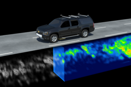
The system works by capturing side-scattered laser light and tracing it back to the perpetrator's location. When a laser is pointed into the sky, a small fraction of its light is scattered by air molecules and aerosols, forming a residual streak in the laser's path. Two or more high-sensitivity, low-noise, charge-coupled device cameras image the scattered light from different vantage points, providing the geometric diversity needed to digitally reconstruct the laser streak in three dimensions. The geographic coordinates of the laser's origin are calculated by tracing the laser streak down to a topographically accurate model of the Earth's surface.
A feature of LASSOS that makes it particularly effective is its integration with Google Earth. As soon as a laser is detected by the cameras, a digital reconstruction of the streak appears on a Google Earth map in real-time. This image summarizes the detection event, depicting the laser's point-of-origin and most probable path through the night sky. Within 30 seconds of the image being captured, LASSOS provides nearby members of law enforcement with the perpetrator's GPS coordinates, nearest address, and the time of the incident. This information allows officers to rapidly intervene.
LASSOS has the potential to diminish both immediate and future threats of laser strikes. Even if lasers strikes do not directly hit an aircraft's cockpit, police officers can use LASSOS to locate the perpetrators and detain them before they have the chance to cause serious harm. Furthermore, data gathered by LASSOS during an incident can be used as evidence in the prosecutions. The developers of LASSOS hope to increase air traffic safety by deterring future laser strikes.
"This technology will significantly increase laser strike origin detection and perpetrator apprehension," says Brian Saar, principal investigator in the laboratory's LASSOS team and an assistant group leader in the Laser Technology and Applications Group. "As culprits are readily apprehended and prosecuted, the appeal of laser strikes as a crime with low risk of detection will decline."
The system prototype has already demonstrated its speed and accuracy in several tests. For one test trial, LASSOS's geolocation ability was tested at a distance of nine nautical miles, to simulate the typical length of a final approach path when an aircraft is most vulnerable to lasing. One sensor was placed on top of the B Building at Lincoln Laboratory and another on the Flight Test Facility at Hanscom Air Force Base. Testers shone high-power laser beams of the type commonly used during lasing events from a baseball field nine nautical miles away in Tewksbury, Massachusetts, and were geolocated by LASSOS in less than 30 seconds. The system was so accurate that it could distinguish whether the laser beams came from first, second, or third base.
Considering LASSOS's promising performance and versatile capabilities, researchers believe that in the future the system could be used to protect other targets of laser strikes, including ships, automobiles, and even individual people.