Over the course of decades or even centuries, Earth’s landscape can appear relatively static, with mountains and valleys seemingly anchored firmly in place. Viewed over a longer timescale, however — on the order of hundreds of thousands of years — the Earth’s topography becomes a rippling, shifting, changing tableau.
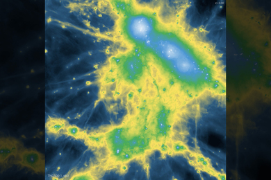
Rivers and valleys, in particular, form intricately branching patterns, the shapes of which have inspired a field of mathematical study in which scientists have developed a theoretical understanding of river-network geometry, and how that geometry might change over time. Now two research groups from MIT, in separate efforts, have come up with mathematical explanations for different characteristics of river and valley networks.
In a paper published this week in the Proceedings of the National Academy of Sciences, Dan Rothman and his colleagues formulate a mathematical theory to discover a common angle at which valleys branch. In environments where erosion is driven by the seepage of water out of the ground, the group’s theory predicts that rivers branch at an angle of 72 degrees.
Putting the theory to the test, Rothman and his group measured 5,000 branching angles in the Florida Panhandle, a region of soft, sandy soils — finding that the average valley branching was indeed 72 degrees. Rothman, a professor of geophysics in MIT’s Department of Earth, Atmospheric and Planetary Sciences (EAPS), says such a mathematical analysis may also be applicable to other systems, such as neuron dendrites and fungal filaments.
Similarly, a team led by Taylor Perron has published a paper this week in Nature in which another mathematical model of river networks has identified a tipping point at which rivers branch. Depending on a river’s capacity to erode a landscape — and how quickly creeping soil may fill its valley — the river may give rise to a dense network of tributaries, or remain as a single rivulet.
“We use mathematics to speed up time and help us understand how these systems evolve,” says Perron, the Cecil and Ida Green Assistant Professor of Geology in EAPS. “If you could speed up the clock, you would see that the landscape is a lot more dynamic.”
Angling for a theory
Near the town of Bristol, along the eastern stretch of the Florida Panhandle, a network of valleys cuts into the landscape, resembling a tree with ever-smaller branches spreading from a main trunk. From an aerial view, one can see midsized branches, or valleys, running with water, and feeding into a wider river. Over time, the very tips of the smallest valleys themselves branch to create an even denser valley network.
To understand how these valleys branch, Rothman and his team — former postdoc Olivier Devauchelle, former graduate student Alexander Petroff and postdoc Hansjoerg Seybold — looked to the mechanics of groundwater flow. Unlike river water that flows over land, groundwater flows under the surface, through material such as porous sand. In an environment such as the Florida Panhandle, groundwater may act to incise, or cut into, a network of valleys: Essentially, groundwater stored in the hills surrounding a valley slowly seeps out, carrying with it some sand. Over time, the process slowly erodes the surrounding hills, extending a valley and eventually splitting it in two.
To find the angle at which this split occurs, Rothman’s group derived a mathematical expression for the paths taken by groundwater as it flows toward a newly split stream. Such paths generally curve either away from each other, when the angle between the streams is small, or toward each other, when the angle is large. However, Rothman’s group found that there is a special angle — 72 degrees — for which the paths are straight, reasoning that this is the angle at which streams branch. They subsequently confirmed their prediction by examining nearly 5,000 stream junctions in the Florida Panhandle.
“What we show is that because of the properties of groundwater flow, one can understand something about the organization of this pattern,” Rothman says. “It opens a world into a really interesting geometry.”
A geologic tug-of-war
In contrast to Rothman’s work, which focused on the effects of groundwater on valley formation, Perron and his colleagues examined the formation of river networks over land. His group sought to answer one main question: What governs the branching pattern that emerges over time?
To answer that question, the researchers developed a simple mathematical model representing the erosional mechanisms that act on a river network. Through their model, Perron found that the shape a river network takes is governed by a tug of war between two forces: the strength of river incision, or how quickly a river erodes its banks and the underlying material; and the strength of soil creep, or how quickly soil from surrounding hills fills in a river valley.
Running the model on a simulated landscape, the researchers found that as they turned up river incision — or turned down soil creep — a river basin with a single river channel morphs into a network of branching channels at a very specific tipping point. Because river incision is stronger in larger river basins that collect more water, this tipping point explains why larger rivers develop a network of tributaries, whereas small rivers may have no tributaries at all.
Moreover, relating the tipping point to specific erosional mechanisms allowed the group to understand why river basins in landscapes with different bedrock or climates grow tributaries at different scales. They predicted that river basins should branch at a smaller size in environments where river incision is strong — for example, areas with heavy rainfall, or soft bedrock — or where soil creep is weak.
Perron tested this prediction in two locations with similar river networks, but at different scales: the Allegheny Plateau, in southwest Pennsylvania, and Gabilan Mesa, in California’s Salinas Valley — a region with similarly-patterned river networks, but at one-quarter the size. The group found that the pattern of river networks in both locations matched predictions from its models, despite their difference in scale and environment.
While Gabilan Mesa has a drier climate than the Allegheny Plateau, its rock is softer and its soil less permeable. On the rare occasions when it does rain hard, the water accumulates faster and cuts more easily into the surface, leading to strong river incision that encourages river branching.
“We tested the model in these two places so we could compare the predicted instability, the breaking point at which rivers should start to branch,” Perron says. “That’s interesting, because it means we can do that for landscapes where we can’t do fieldwork — possibly landscapes on another planet.”
Mikael Attal, a lecturer in landscape dynamics at the University of Edinburgh, says the results from both Perron’s and Rothman’s work shed light on what may cause such intricate patterns in rivers and other natural landscapes.
“Understanding how river networks originate and evolve is key to understanding how landscapes have evolved in the past, and how they will evolve in the future,” says Attal, who did not participate in the research. “What is fascinating about these two papers is that they provide a physical explanation for the geometry of river networks using some very simple concepts. Studies such as these will help better parameterize models and help make more accurate predictions of what may happen in the future.”