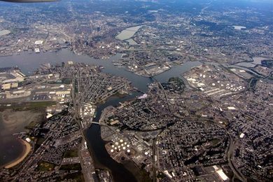
Maps, Geographic Information Systems, and spatial analysis are powerful tools that recently have become increasingly accessible to non-specialists. Dynamic maps with user-created content are becoming part of daily life in the 1/3 world (developed countries and elites in the global South). There is a long history of maps as tools for civic engagement, with public participatory GIS and community engaged mapping playing key roles in (for example) indigenous land rights struggles, mapping health disparities, and the environmental justice movement's demonstration of the unequal spatial distribution of pollution. Most recently, new tools and platforms such as Open Street Maps and Grassroots Mapping are democratizing maps even further.
What challenges still constrain the effective creation and use of Civic Maps? What tools and platforms are most promising? What steps can developers, practitioners, and researchers take to help build the field of civic mapping? This will be discussed from 5-7 p.m. on Thursday, Oct. 20, in E14-633 at the Civic Media Session: "Civic Maps" event.
What challenges still constrain the effective creation and use of Civic Maps? What tools and platforms are most promising? What steps can developers, practitioners, and researchers take to help build the field of civic mapping? This will be discussed from 5-7 p.m. on Thursday, Oct. 20, in E14-633 at the Civic Media Session: "Civic Maps" event.